 🇬🇧 Aconita DevLeaks
DevLeaks
The Tactical Map
In this DevLeak, I would like to share a few more details about the world and, in particular, the characteristics of its regions.
As you already know, regions have a predominant climate, terrain type, and level of vegetation, all of which are already shown on the main map. In the world of Aconita, however, regions have another underlying layer that offers a much higher level of detail. Today, I would like to talk about precisely that layer.
Each land region has its own unique landscape, represented by a map consisting of 20x20 hexagonal tiles. This is the Tactical Map.
Each tile represents an area of 2x2 km, which serves as the basis for numerous other values and mechanics in the game, such as the rules governing unit movement and city development (which will be described in detail in future DevLeaks). Ocean and sea regions do not have individual landscapes, as they consist entirely of water tiles. Even the smallest islands in the sea therefore consist of at least one land region surrounded by six coastal regions (one in each direction).
The appearance of the tactical map and its tiles naturally reflects the predominant climate of the region it belongs to. You will see muddy, earthy colours in wetlands, for example, or fresh shades of green in grasslands. In addition, each tile can have a special terrain feature, such as hills, lakes, and the like. A region's dominant climate determines its average temperature and moisture level, which have a huge impact on the appearance and physical characteristics of its landscape. So you should not be surprised to discover vast swamps in wetlands or dense coniferous forests in boreal regions.
A region's average elevation is another important value. It serves as a rough measure of how varied the region's terrain is. Mountain regions have large differences in elevation, unlike plains, whose terrain is much more uniform. Hilly regions fall somewhere in between.
Now, let us take a look at the possible terrain features a tile can have:
- Hills:
Naturally, you will find more hill tiles in mountains or hill country than in plains. Even so, you may discover high plateaus in the mountains, as well as areas with tall peaks in otherwise completely flat regions. Hills affect unit movement and offer certain advantages to defending units in combat. They also provide a greater chance of finding certain raw materials. Hills do not occur in coastal or glacier regions. - Lakes:
When you look at the main map, you will generally not see any lakes, but you will find inland lakes on the tactical map. We distinguish between two types of lakes. The first has an inflow from at least one river and an outflow, while the other has no connection to any river. Various parameters influence how these lakes form.
- Every river has a certain chance of encountering a depression along its course, where its water collects and forms a lake. The larger the river, the more water it carries, and the larger the lake can become. A lake can have several inflows but only one outflow, as water always drains away along the easiest, most direct route.
- The higher a region's elevation and the more varied its terrain, the greater the likelihood of water collecting in depressions and forming lakes. You can therefore expect more scattered lakes in the mountains than in lowland plains. Plains tend to have fewer lakes, but where enough water is available, these lakes can cover a larger area.
- The third factor is the region's overall moisture level. Wet regions have more water than dry ones, which affects the potential size of their lakes. Lakes cannot be crossed without boats. They provide drinking water and other resources, such as fish.
- Swamps:
Swamps form in moist environments, near lakes and rivers. They do not occur in deserts, ice regions, or glaciers, as these regions are too dry or too cold. While swamps have a low chance of occurring in tundra, steppe, or savanna regions, you can be almost certain to find some extensive swamps in wetland regions. All other regions have a moderate chance of containing swamps.
Swamps are difficult to cross unless a surfaced road runs through them. Later in the game, it will be possible to drain swamps. - Rocks:
In the game, rocks is a general term covering any rock formation, individual mountain, or even an entire mountain massif. You can find them in any region, although they are somewhat more common at higher elevations. Moisture and erosion also affect the likelihood of rock formations occurring.
Rocks are normally impassable, but with sufficient knowledge of construction, it will be possible to build tunnels through them. - Beaches:
Beaches are the land tiles within coastal regions. Coasts are defined as the transition between land regions and sea regions. They consist mainly of water tiles and are the only regions with access to both the sea and the inland areas. Beaches are the tiles that can be reached from land regions and therefore lie adjacent to them.
Harbours and shipyards can only be built on beach tiles that border water. Ships arriving from the sea (such as invasion fleets) always require a beach to make a successful landing. - Forests:
You can expect forest tiles to cover up to 90% of the landscape in boreal, forest, and jungle regions. Glacier and coastal regions, on the other hand, have no forested areas. Although there is a small chance of oases occurring, regions without vegetation (most deserts and ice regions, as well as some tundra and steppe regions) will generally have no trees either. All other regions have at least some tree cover, with the amount depending on their vegetation level.
Rivers are an important part of the tactical map and follow a detailed course. Their entry and exit points are, of course, not arbitrary: they match those on the tactical maps of neighbouring regions. The same applies to all other special terrain features, allowing hills, lakes, swamps, and rocks to extend across regional boundaries into the tiles of neighbouring regions.
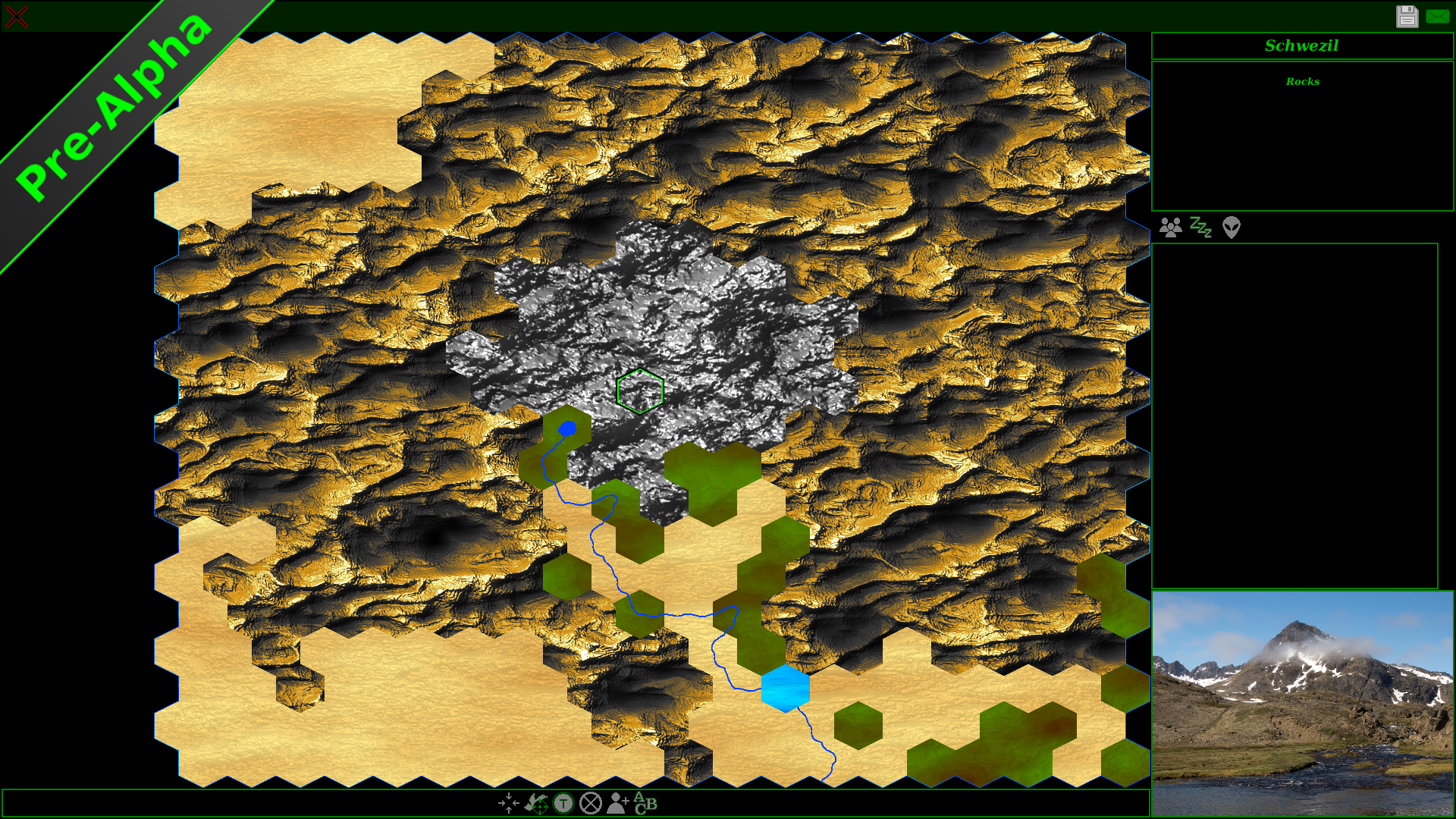
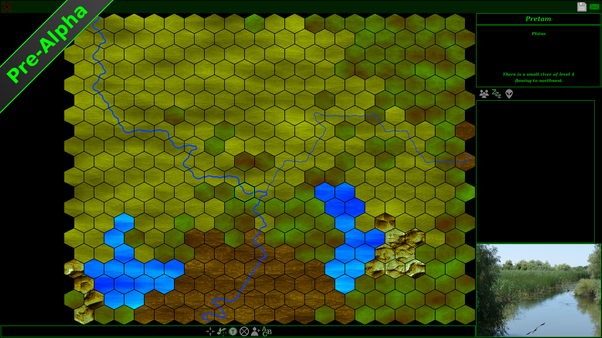
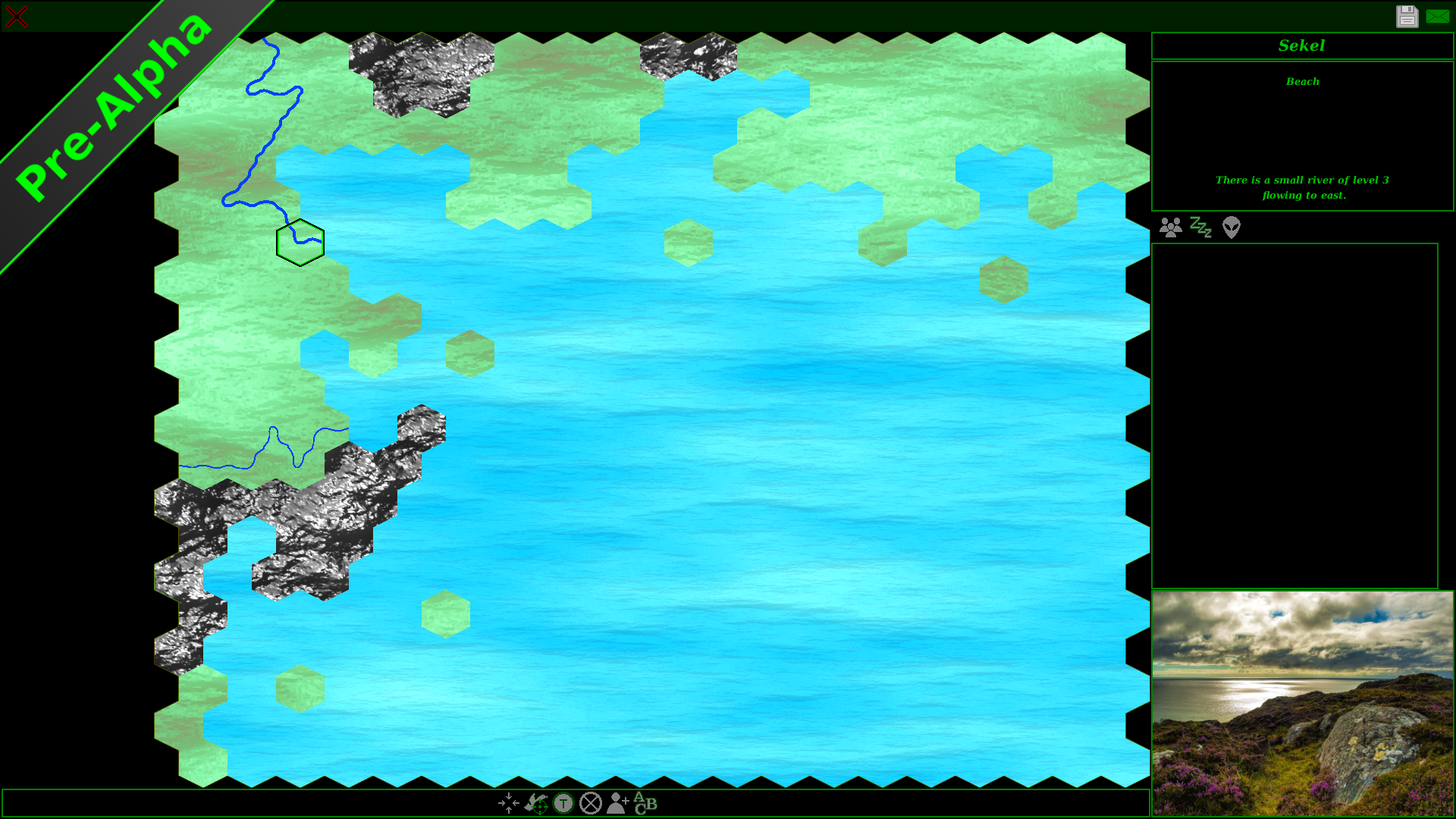
To give you a visual impression of the tactical map, I would like to show you three screenshots from three different regions.
The first shows a landscape with a dry mountain range in a steppe region. In the centre of the region, you can see a rocky massif surrounded by numerous hills. A small stream winds southeast from its source, passing through a small lake along the way. You can see a few forest tiles; all remaining tiles are ordinary plains without any special features.
The second screenshot shows the details of a flat wetland region. In the south, you can see a large swamp lying between two lakes. A level 3 river flows from the south towards the northwest, and in the centre of the image, you can see a small stream joining the larger river. The optional grid overlay is also enabled in this screenshot.
The final image shows a typical coastal region in a cold environment. As you can see, there is only a small stretch of beach to the north and west, with a few rock formations; most of the tiles are water.
3. The Tactical Map
2. The World
1. The Idea